
Good rain chances to last through the workweek
Sunday, August 24, 2025
Temperatures are in the upper-seventies with cloudy skies this Sunday mid-afternoon in Steamboat Springs. You don’t have to be a meteorologist to know the weather pattern has shifted, with our best monsoonal surge of the summer arriving today and lasting through the workweek. While some rainfall is almost certain over the entire state, timing, rainfall rates, and duration are uncertain, as is often the case during the North American Monsoon.
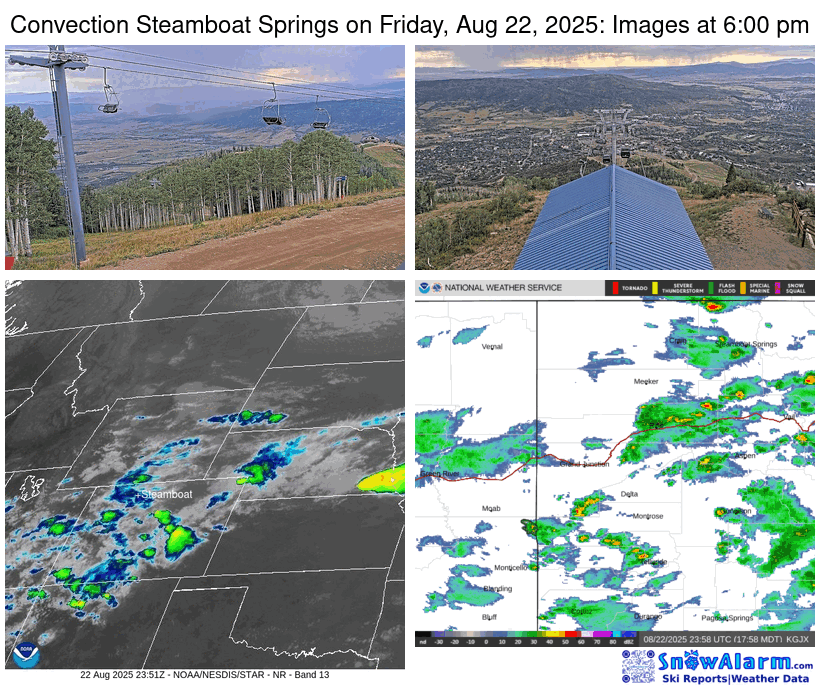 Before discussing the weather forecast, the thunderstorm last Friday exhibited similar characteristics to those that occurred exactly a week ago, when a thunderstorm rapidly intensified as it moved over town, approaching this time from the northwest rather than the southwest.
The image in the lower-left of the mosaic animation is the infrared satellite, which measures cloud-top temperatures; the higher the cloud, the colder the temperature, the more colorful the image, and the stronger the thunderstorm. The location of Steamboat Springs is marked in white, and the rapid intensification of the storm cell is noted by the rapidly growing green blob that moves over town. The propagation of the storm through town is captured first by the sequence of images from the Thunderhead cam in the upper right as the rain approaches from the northwest, and then the Four Points cam in the upper left as it moves over the Steamboat Ski Resort.
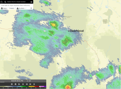 While the red colors of the radar images in the lower right panel indicate a strong storm, it is apparent that the cell splits as it moves over town. The second animation shows a high-resolution radar view of the splitting storm. Not only does the initial thunderstorm split when it moves over town, but additional thunderstorms from the north merge with both parts of the split storm, illustrating the difficulty in making even a real-time forecast, or nowcast, of shower development.
But now we are in a new weather regime as the ridge of high pressure responsible for the record-breaking heat last week is forced eastward by low pressure approaching the West Coast. Clockwise flow around the high pressure has conspired with southerly winds ahead of the approaching low pressure to bring a surge of monsoonal moisture northward.
Good rain chances starting this afternoon and lasting through much of the workweek result, with high temperatures cooling into the upper-seventies on Monday and Tuesday, near our average of 79 F, and lower-seventies on Wednesday and Thursday. Overnight rainfall is possible, even likely at times, with the strength of daytime thunderstorms dependent upon morning cloud cover. Morning sun will cook the moist atmosphere, allowing stronger thunderstorms later in the day, while morning clouds will allow for a gentler and steadier rain.
The best day for showers is Wednesday, which is incidentally the coolest day of the week, as the low pressure off the West Coast is forced inland by a storm moving southeastward through the Gulf of Alaska. This is also when snow levels drop below 14,000′, perhaps leading to the first dusting of snow on Colorado’s highest peaks Thursday and Friday mornings.
Rainfall for our area is forecast to be significant, between one and one-and-a-half inches, and is sorely needed. The monsoonal moisture tap is forecast to be severed by the end of the work week by westerly winds associated with the Gulf of Alaska storm as it approaches the Pacific Northwest, bringing a warming and drying trend into next weekend.
Let’s hope the moisture arrives beneficially with light to moderate rainfall rates, as heavy downpours will be problematic around recent burn scars. Relish the wet workweek ahead, and I’ll have more details about the weekend’s forecast in my next regularly scheduled weather narrative on Thursday afternoon.
Add comment
Fill out the form below to add your own comments


